Subject: Virginia
Period: 1867 (dated)
Publication:
Color: Printed Color
Size:
33.1 x 21.6 inches
84.1 x 54.9 cm
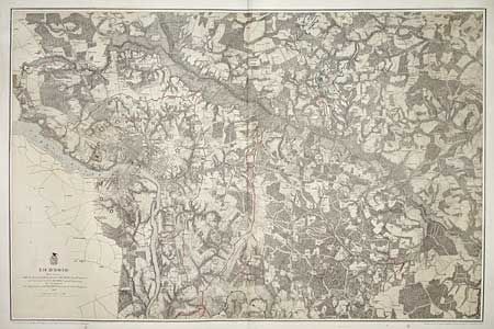
This superb Civil War military map was issued in a U.S. War Department report illustrating the Operations of the Armies of the Potomac & James. The maps were beautifully lithographed and hand colored by Julius Bien of New York. Each large-scale map features incredible detail including roads, houses, fences, names of inhabitants, vegetation, drainage, and relief hachures. Maj. J.E. Weyss drew these maps from surveys under the direction of Bvt. Brig. Gen. N. Michler and Bvt. Lieut. Col. P.S. Michie under the command of Bvt. Maj. Gen. A.A. Humphreys.
Very detailed Civil War map of the vicinity of Richmond and eastward about 16 miles to include all battle lines in color. Shows common roads, railroads, fortifications (Union in blue; Confederate in red). Richmond and Chester are shown with street detail. A ring of heavy fortifications surround and defend Richmond and Chester.
References: Phillips [A] Vol. 3 #3688.
Condition: A
A couple of insignificant spots in blank area near title.