Subject: Nebraska
Period: 1894 (published)
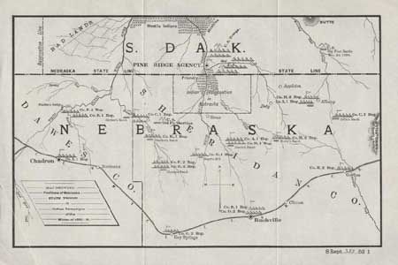
Publication: Expenses incurred by Nebraska in a raid by the Sioux Indians, Sen. Report #352
Color: Black & White
Size:
12 x 7.5 inches
30.5 x 19.1 cm
This map has considerable historical significance in that it shows the location of the Battle of Wounded Knee, here labeled as Big Foot Battle, Dec 29, 1890. A misunderstanding between soldiers and Indians waiting to surrender at Wounded Knee, South Dakota, touched off the tragic massacre of some 300 Sioux men, women and children. The campaign was an attempt to suppress the Ghost Dance movement. At the height of the tension, Sitting Bull was killed. The map covers a portion of South Dakota and Nebraska and includes Madden's Bridge, the Stryker, Chaney, Swallow, Jarcho, Morey and Collin Ranches, and the towns of Pine Ridge, Gordon, Rushville, and Chadron. Military positions are shown throughout. Notes friendly and hostile Indian locations. A fascinating map.
References:
Condition: A
Clean and bright with good impression. Folding as issued, with printer's crease at lower left corner