Subject: Florida
Period: 1839 (dated)
Publication:
Color: Hand Color
Size:
29 x 40.2 inches
73.7 x 102.1 cm
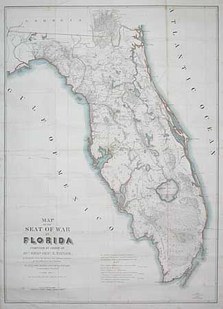
By Capt. John Markey and Lieut. J.E. Blake. This is a remarkable and early map of Florida at the time of the 2nd Seminole War. Remarkable detail includes Army forts, battlegrounds, vegetation, hydrology, and a large network of roads and trails; many labeled with the related military action. Crossed swords are used as an icon to locate battles. Locates many Seminole villages. Hand colored in outline with the numerous forts highlighted in orange. An area outlined in red indicates an area assigned to the Seminoles by arrangement of Gen. Macomb on May 18, 1839. The panhandle west of Tallahassee and the Ocklockonee River is not included. A large, scarce and seldom offered map.
References: Claussen & Friis #316; Phillips (A) p. 284.
Condition: B
Backed with Japanese tissue and pressed. A few spots with toning along one fold, and a little surface soil. Still a good example for a map of this size.