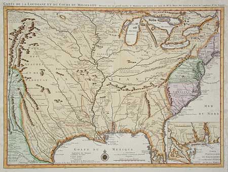
Subject: Colonial Louisiana Territory
Period: 1730 (circa)
Publication:
Color: Hand Color
Size:
23.7 x 17.2 inches
60.2 x 43.7 cm
Delisle's influential map of the French possession of Louisiana that drew together the cartographic work of the previous half century and had a tremendous impact on the history of cartography. When originally published in 1718, it was the first detailed map of the Gulf region and the Mississippi, and the first to show the explorations of De Soto, Cavelier, Tonty, Moscoso and Denis. The name Texas made its first appeared in print on this map, with the legend Mission de los Teijas, that was established in 1716. Inset of Mississippi delta and Mobile Bay. This is the Covens & Mortier issue, updated to include New Orleans.
References: Cumming (SE) #208; Tooley (Amer) p.22, #45; cf. Wheat (TMW) #99; cf. Martin & Martin #19.
Condition: B
Professional restoration of paper in margins, including some expert facsimile of title, else very good.