Subject: Colonial Canada and Great Lakes
Period: 1755 (dated)
Publication: Atlas Universal
Color: Hand Color
Size:
23.8 x 18.6 inches
60.5 x 47.2 cm
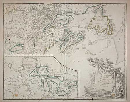
Lovely map depicting Newfoundland, Nova Scotia, and the entire course of the St. Lawrence River and a very large inset of the 1744 Bellin version of the Great Lakes. The large decorative cartouche features a rather fierce-looking beaver below the title. This is the third state of the map, which underwent numerous changes. A dashed line was added surrounding the Province of Quebec, and Nouvelle Ecosse was added in Nova Scotia. The northern boundary of New York was eliminated, and the boundary of New England was extended north to include most of present-day Maine. A dashed boundary was added south of Lake Ontario to represent the 1768 Treaty of Fort Stanwix. Dated 1755 but published circa 1768.
References: Kershaw #356; Pedley #459.
Condition: B
Wide margins, but with slight chipping at paper edges. A couple of small spots in map and light water stain in lower margin just into border.