"Map Illustrating the Extermination of the American Bison Prepared by W.T. Hornaday", Smithsonian Institute
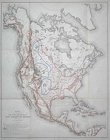
Subject: North America
Period: 1890 (circa)
Publication: HR Misc. Doc., 50th Cong., 1st Session
Color: Printed Color
Size:
17.5 x 22.1 inches
44.5 x 56.1 cm
Prepared by W.T. Hornaday for a report to the U.S. National Museum, Smithsonian Institution. This map traces in red the boundary of the area once inhabited by the buffalo (American Bison). The area in blue and green reflects the tragic and systematic destruction of these herds for robes, hide etc. The numbers in green represent the locality and number of the wild buffalo in existence by January 1, 1889. Barely 800 bison are known to exist when this map was published. A historically important and poignant map that is seldom offered. Read portions of Hornaday's report.
References:
Condition: A
Folding, as issued. Near fine condition.