Subject: North America
Period: 1794 (dated)
Publication: General Atlas
Color: Hand Color
Size:
46 x 20 inches
116.8 x 50.8 cm
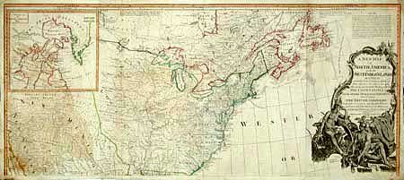
The map "A New Map of North America with the West India Islands divided according to the Preliminary Articles of Peace, Signed at Versailles, 20 Jan. 1783 wherein are particularly Distinguished The United States…" is a tour de force that is filled with Indian tribes, rivers, towns and villages, early roads, and many notations, a few reproduced here. The most prominent notation reads, in part, thus: "Article III, It is agreed that the People of the United States, shall continue to enjoy unmolested the Right to take Fish of every kind on the Grand Bank, and on all other Banks of Newfoundland, also in the Gulf of St. Laurence, and at all other Places in the Sea…" Another reads "The Divisions in the Map are Coloured according to the Preliminaries Signed at Versailles, January, 20th, 1783." The colors used are red for British, Green for the United States, Blue for French, and Yellow to show Spanish possessions.
Fabulous British wall map on two joined sheets. This is the northern half of this rarely seen map and is the portion showing most of the United States and with the title cartouche. It was originally drawn by Emanuel Bowen and engraved by John Gibson in 1755 to illustrate the French & Indian War. It was revised numerous times, going through a number of title changes and publishers over its long publication. Beginning the 1770s, the map was updated to include surveys compiled by Governor Thomas Pownall, including information from Evans' and other indigenous sources. Governor Pownall’s name first appeared on the map in 1777 and the map was updated to show the newly formed United States in 1783. It provides an extremely detailed view, locates hundreds of settlements and Indian villages, locates many early roads, and is filled with interesting notations. Article III of the fishing treaty is given above the cartouche. The large cartouche features Native Americas and indigenous animals. Very large inset titled "A Particular Map of Baffin and Hudson's Bay" is a great map in its own right. Beautiful, dark impression, particularly in the cartouche. Offsetting in the ocean, and in western portion opposite cartouche. A beautiful and scarce map that will benefit from professional restoration.
References: Stevens & Tree (MCC-39) #49.
Condition: B
Two areas of loss at sides about 2"x1" entering border and just into map, with new hand laid paper attached from back with facsimile.