Subject: Japan
Period: 1683 (circa)
Publication: Description de l'Univers
Color: Black & White
Size:
4.2 x 5.8 inches
10.7 x 14.7 cm
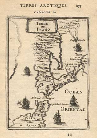
A fine miniature map of the northern part of Japan depicting the Dutch discoveries of Maerten Gerritsz de Vries in 1643. It is the first European printed map that is exclusively devoted to Ezo. Kunashiri is depicted here as the continuation of the Nemuro Peninsula. Etorofu is referred to as Terre des Etats, and the western side of Urup as Terre de la Compagnie. The Detroit d'Vries and Detroit de Sungar are also named. The depiction of the northern tip of Honshu is a striking deviation from Mallet's map of Japan that was issued in the same atlas. Five sailing ships decorate the map.
References:
Condition: A
Crisp impression. Short tear at left just touching neatline, stabilized with archival tape.