Subject: Virginia
Period: 1867 (dated)
Publication:
Color: Hand Color
Size:
18.2 x 30 inches
46.2 x 76.2 cm
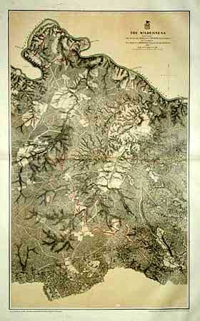
This superb Civil War military map was issued in a U.S. War Department report illustrating the Operations of the Armies of the Potomac & James. The maps were beautifully lithographed and hand colored by Julius Bien of New York. Each large-scale map features incredible detail including roads, houses, fences, names of inhabitants, vegetation, drainage, and relief hachures. Maj. J.E. Weyss drew these maps from surveys under the direction of Bvt. Brig. Gen. N. Michler and Bvt. Lieut. Col. P.S. Michie under the command of Bvt. Maj. Gen. A.A. Humphreys.
This really was the wilderness - there are only a tavern, a store, couple of farmhouses, a barn, an unfinished railroad and the Old Wilderness Church on the entire sheet. The locations of the forces are identified by red and blue lines. Scale 3 inches = 1 mile.
References: Phillips (A) Vol 3, #3688-4.
Condition: A
Light spot well away from image.