Subject: Virginia
Period: 1867 (dated)
Publication:
Color: Hand Color
Size:
18.7 x 15.5 inches
47.5 x 39.4 cm
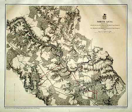
This superb Civil War military map was issued in a U.S. War Department report illustrating the Operations of the Armies of the Potomac & James. The maps were beautifully lithographed and hand colored by Julius Bien of New York. Each large-scale map features incredible detail including roads, houses, fences, names of inhabitants, vegetation, drainage, and relief hachures. Maj. J.E. Weyss drew these maps from surveys under the direction of Bvt. Brig. Gen. N. Michler and Bvt. Lieut. Col. P.S. Michie under the command of Bvt. Maj. Gen. A.A. Humphreys.
Single page map of the Civil War battlefield area. Very detailed on a scale 3 inches = 1 mile. The background is fully colored with troop entrenchments colored in blue and red. A great battle plan printed on heavy paper.
References: Phillips (A) #3688-6.
Condition: A
Marginal stains.