Subject: Alaska
Period: 1799 (published)
Publication: Vancouver's Voyages (French Edition)
Color: Black & White
Size:
24 x 30 inches
61 x 76.2 cm
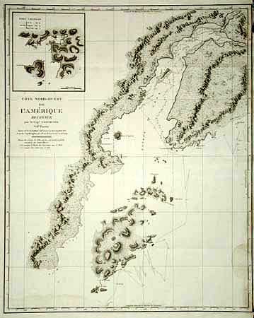
Superb large-scale map featuring the coastal topography of Kodiak Island and Cook Inlet with the track of Vancouver's exploration in 1794 complete with soundings. Inset of Port Chatham. During the summers of 1792-94, George Vancouver and the crew of the British naval ships Discovery and Chatham mapped the northwest coast of North America from Baja California to Alaska. Vancouver's voyage was the last, and longest, of the great Pacific voyages of the late eighteenth century. Taking the art and technique of distant voyaging to a new level, Vancouver eliminated the possibility of a Northwest Passage and his remarkably precise surveys completed the outline of the Pacific.
References: Falk #1799-7, Hayes #148.
Condition: B
Very minor damp stain at bottom and chipping in upper right margins with loss just to neatline.