Subject: Western United States
Period: 1853 (dated)
Publication: Senate ex Doc. 29, 33rd Cong., 1st Session
Color: Black & White
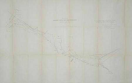
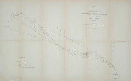
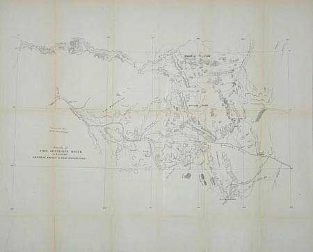
1. "Sketch of Capt. Gunnison's Route to Central Pacific R. Road Exploration", Sept. 20th 1853, 20.5 x 13". Indians killed Gunnison and the survey was completed by Lt. Beckwith. This is a great early map of present-day Colorado - rarely seen on the market. It depicts several exploratory routes in the Rocky Mts. 2. "Sketch of the Northern Pacific Rail Road Exploration from St. Paul to Fort Union", by Isaac Stevens, 1853, 32 x 17". This map shows Stevens exploratory route and the route of Lt. Grover from Pike Lake to Ft. Union. 3. "Sketch of the progress of the Northern Pacific Rail Road Exploration up to the crossing of the Shayen River", by Isaac Stevens, 1853, 25 x 15.5". Includes a lower route from White Bear Lake to Shayen, the Red River Trail. Wheat notes that these three maps are earlier versions of the maps contained in the quarto version of the Pacific Railroad Surveys and Explorations.
References: #1 - Koepp, No. I-127-2-4, No. 695; #2 & #3 Wheat (TMW) 861.
Condition: B
All with toning along some folds. Backed with archival tissue and pressed.