Subject: Western United States
Period: 1852 (published)
Publication: Exploration and Survey of the Valley of the Great Salt Lake…
Color: Hand Color
Size:
66 x 28 inches
167.6 x 71.1 cm
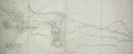
Made under the orders of Col. J.J. Albert, chief of the Topographical Bureau, by Capt. Howard Stansbury of the Corps of Topographical Engineers, aided by Lieut. J.W. Gunnison and Albert Carrington. Drawn by Lieut. Gunnison and Charles Preuss. Thus bringing together some of the most important names in Western cartography. This immense map covers the Great Plains, Colorado, Wyoming and Utah in considerable detail on a scale of 1" to about 16 miles. The detail is particularly evident in present-day Colorado, the Laramie Mountains (here labeled Black Hills), and in the vicinity of Salt Lake. Wheat devotes more than eight pages of text to this map, calling it "one of the most important [maps] of its decade…bringing permanently into Western cartography a number of outstanding details."
References: Wheat (TMW) # 764.
Condition: B
A little toning and a couple of splits at fold intersections, otherwise very good. Later color added to title letters.