Catalog Archive
Auction 98, Lot 133

"[Great Plains: Fort Leavenworth to Santa Fe]", U.S. War Department

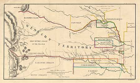
Subject: Western and Midwest

Period: 1860 (circa)

Publication: American State Papers, Military Affairs, Vol. VL

Color: Hand Color

Size:
17.5 x 10 inches
44.5 x 25.4 cm
Download High Resolution Image
(or just click on image to launch the Zoom viewer)

Map detailing the 1835 expedition of Dragoons under the command of Colonel Henry P. Dodge. The map, attributed to Lt. Steen, extends from Pike's Peak and Santa Fe in the west and east to Fort Leavenworth. It locates rivers, creeks, mountains, Indian Reservations, Indian villages, Indian lands, military posts, the Santa Fe Trail, etc. Originally published HR Doc. 181, 24th Cong., 1st Session, in 1836. A landmark map for illustrating land holdings of the Western Indians.

References: Wheat [TMW] 411.

Condition: A

Good impression that is well colored. Backed with Japanese tissue with margin extended at binding side.

Estimate: $150 - $250

Sold for: $275

Closed on 3/6/2002

Archived