Catalog Archive
Auction 98, Lot 116

"Partie de la Carte du Capitaine Cluny Auteur d'un ouvrage anglois intitule American Traveller", Robert de Vaugondy, Didier

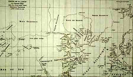
Subject: Canada and Alaska

Period: 1772 (circa)

Publication: Diderot's Encyclopedia (Supplement)

Color: Black & White

Size:
19.4 x 11.5 inches
49.3 x 29.2 cm
Download High Resolution Image
(or just click on image to launch the Zoom viewer)

Depicts North America from above the Arctic Circle, to the Gulf of Mexico. The most important feature of the map is the early depiction of what is present day Alaska, and is patterned after Muller's epic map of 1750 that was the first to show the Russian discoveries, also noted here. A very interesting Northwest Passage is shown going from Repulse Bay in the north part of Hudson's Bay into the Arctic Ocean at a place called Cape Fowler. Good detail of Baffins Bay and Hudson Bay. This is the larger edition of this map.

References: Wagner (NW) #637-10.

Condition: A

Tiny bit of insignificant foxing, overall very good. Small tear in bottom margin, well away from map.

Estimate: $200 - $250

Sold for: $180

Closed on 3/6/2002

Archived