Subject: Colonial Mexico and Southwest
Period: 1561 (published)
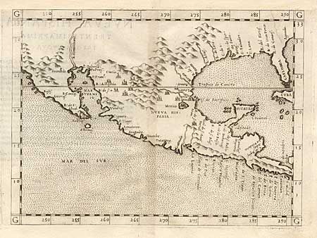
Publication: La Geografia di Claudio Tolomeo
Color: Black & White
Size:
9.7 x 7.2 inches
24.6 x 18.3 cm
This fine early map of New Spain is an enlarged version of Gastaldi's map of 1548 with the only notable change being the peninsular Yucatan. California is a peninsula and in the vicinity of the Colorado River flows the R. Tontonteanc. The legendary seven cities of Ciuola are noted and Mexico City is shown floating in a large lake. The place names along the upper Gulf Coast reveal the explorations of Pineda, Cabeza de Vaca and Moscosso. The Mississippi makes its appearance as the Rio de Spiritu Santo. Considered the earliest relatively obtainable map of Mexico and the American Southwest. First state.
References: Burden #31; Martin & Martin, plt. 3.
Condition: B
Margin trimmed and replaced at top (removing title) with an old repair at top left. Minor toning along fold.