Subject: Mexico
Period: 1845 (published)
Publication: New Universal Atlas
Color: Hand Color
Size:
14.7 x 11.7 inches
37.3 x 29.7 cm
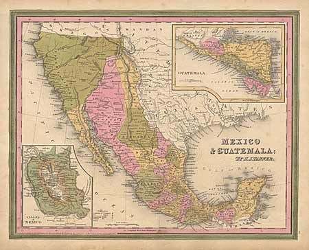
Features a Texas configuration that fits between the republic period and early statehood. New Mexico extends north into the western part of present day Colorado. It's panhandle here is still labeled "Santa Fe." Upper California occupies much of the West. The rivers Timpanogos and San Buenaventura run straight through the Great Basin into the Pacific. Sonora extending north as far as New Mexico. Filled with detail, Indian Tribes and much more. This map is believed to be from the rare Carey & Hart edition based on the border with outer green and inner pink. Dated 1834 but published in 1845. An important and interesting map.
References:
Condition: B
Minor light foxing.