Catalog Archive
Auction 97, Lot 213

"Plat of the Seven Ranges of Townships being Part of the Territory of the United States N.W. of the River Ohio Which by a late act of Congress are directed to be sold at public auction in Pitsburg…", Hutchins, Thomas (Capt.)
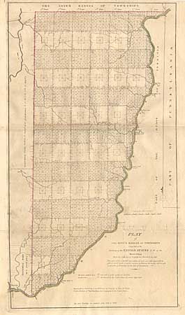
Subject: Ohio

Period: 1814 (published)

Publication: Mathew Carey's General Atlas

Color: Hand Color

Size:
13.2 x 24 inches
33.5 x 61 cm
Download High Resolution Image
(or just click on image to launch the Zoom viewer)

Copperplate engraving, with original outline hand color. Thomas Hutchins (1730-1789) was the first and only official Geographer to the United States, who in accordance with the Ordinance of 1785 conducted the first survey that divided public land into townships and ranges, standards of land measurement with subsequently became very common. While the Hutchins' map is copyrighted 30 September, 1796, it was not until 1815 that the township plat, a "planimetric base map that laid down legal subdivisions in each township" assumed its modern form. According to Schwartz & Ehrenberg, even then the task of regulating the standard of land measurement underwent many changes. Rightly famous for being the first of its kind.

References: Phillips (A) 722-28; cf Wheat & Brun 677.

Condition: B

Lightly toned with a little offsetting and a small area of surface soiling.

Estimate: $400 - $500

Sold for: $300

Closed on 12/5/2001

Archived