Subject: Central United States
Period: 1838 (dated)
Publication:
Color: Black & White
Size:
14.2 x 23.5 inches
36.1 x 59.7 cm
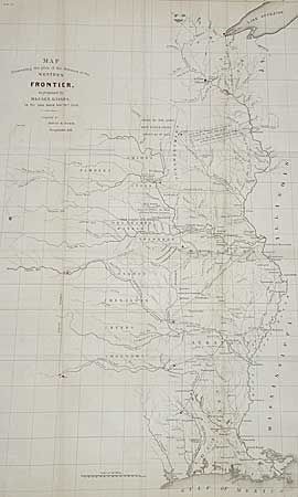
This map was issued as part of the continuing debate over the nature of the Frontier Defenses between the Mississippi River and the Rocky Mountains. General Edmund P. Gaines, one of the most visionary military men of the 19th century, set out this proposal. His plan called for a system of military railroads that would permit the rapid movement of troops, not only between St. Louis and the frontier, but between Atlantic coastal forts and western frontier forts. In the 1830's this was a revolutionary idea, as railroads were in their infancy with only a few local lines connecting eastern cities. The map depicts the United States territory west of the Mississippi River, including lands making up present-day Louisiana, Arkansas, Missouri, Iowa, Minnesota, Nebraska, Kansas and Oklahoma. Lands claimed and ceded by various Native American tribes, and lands assigned to tribes are indicated, as well as proposed forts and railroads. This map is part of a series, together with those illustrating the proposals of J.R. Poinsett and Charles Gratiot, which provide a fascinating comparison of the region, locating many military forts and outposts from Ft. Jessup to Ft. Snelling. Uncolored except for red marking the locations of the forts.
References: Wheat (TMW) #432
Condition: A
Minor toning.