Subject: Atlas
Period: 1757-1763 (published)
Publication:
Color:
Size:
5.9 x 9.2 inches
15 x 23.4 cm
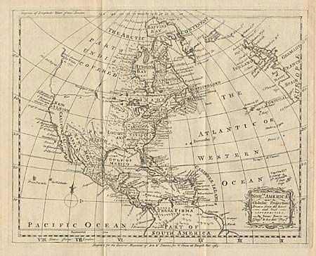
This is an assemblage of seventeen maps (mostly folding) engraved by Emanuel Bowen for the magazine. They are variously dated from 1757 to 1763. Nine of the maps relate to North America and the Caribbean including two identical maps of the West Indies. They are: The Island of Martinico…; An Accurate Map of the Island of Guadaloupe…; A Plan of the City of Quebec; An Accurate Map of the West Indies (2); North America upon the Global Projection; A Map of the British and French settlements in North America (First part covering Canada and New England); A Map of the British and French settlements in North America (Second part covering south from Pennsylvania to Florida and Louisiana); A New geographical Map or Chart of the Atlantic Ocean. The other maps include continental maps of Africa, Asia and South America, two identical maps of the East Indies, with the balance being regions of Africa and South America. The maps have been bound into a lovely half calf binding with marble paper boards and gold embossed title on spine.
References:
Condition: A
Maps generally toned with a little offsetting and a few repairs, else very good, binding mint.