Subject: World
Period: 1755 (published)
Publication: Gentleman's Magazine
Color: Black & White
Size:
11.2 x 7.2 inches
28.4 x 18.3 cm
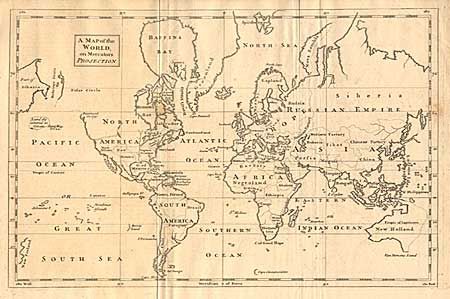
Jolly called this "a neatly executed map showing the state of discovery with little fanciful speculation." The west coast of North American is labeled New Albian and a note in the Pacific reads "Land discovered in 1741, see Gent. Mag. Vol. 24.” The entire eastern coast of Australia is indicated as unknown by a dotted line and Van Dimens Land is shown connected to the continent. Only the western side of New Zealand is shown. Cape Circumcision floats alone in the south Atlantic well below the Cape of Good Hope.
References: Jolly GENT-94.
Condition: B
Thick hand-laid paper with large watermark. Even age toning and a couple light spots.