Subject: California
Period: 1850 (published)
Publication:
Color: Black & White
Size:
19.8 x 21 inches
50.3 x 53.3 cm
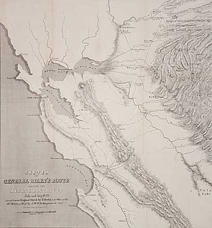
Important GOLD RUSH map of the gold region in northern California. The map was made from the original sketch by Lt. Derby in the office of the 10th Military Dept. It is historically important, not only for its depiction of Gen. Riley's route, but because it names, for the first time, certain actual mining camps in the middle Sierra foothills, Mormon Island (misspelled Mormont), Coloma (mislabeled Colluma), Curtis, Sullivan's, Corons, Jamestown, Woods and Sonora. The entire route of the Riley party is noted, with the dates of their visits to the various camps. It covers the region from Monterrey Bay, north to Sacramento and east to the gold diggings.
References: Wagner-Camp-Becker 179 b: I & 2; Wheat (Gold), #79.
Condition: A
Folding, as issued. A nice example of this important map.