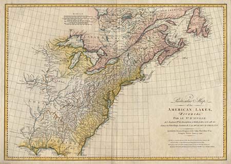
Subject: Eastern United States
Period: 1790 (dated)
Publication:
Color: Hand Color
Size:
28.1 x 19.7 inches
71.4 x 50 cm
A large map of the United States issued shortly after Independence. D'Anville’s map was originally issued in 1755, with this revised edition drawn and engraved by John Harrison in a slightly smaller format. D’Anville had direct access to the official French records of North America, and so his American maps are known for their excellent and clearly presented detail. Though the map is focused on the rivers and lakes, it also contains good information on towns and Native American settlements. The Mississippi and its tributaries, including the lower part of the Missouri, are shown with good information.
References: McCorkle #790.1.
Condition: A
Barely noticeable mildew in title, overall very good with attractive color.