Subject: Italy
Period: 1557 (dated)
Publication: Geograpfia tavolo moderna….
Color: Black & White
Size:
15 x 11 inches
38.1 x 27.9 cm
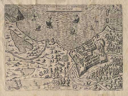
A scarce map from a very rare composite atlas published by Antonio Lafreri. Though the exact maker of this map is unknown, the maps from the Lafreri atlases were engraved by such notables as Gastaldi, Camocio, Forlani and Bertelli, and were often the basis of Ortelius' later maps of the Mediterranean. This map is an incredibly detailed bird's-eye view of the fortified city of Nettuno and the Port of Anzio. The surrounding countryside is complete with cultivated fields, houses, towers and forests. The bay is filled with ships and boats.
References: Nordenskiold #20; Tooley (MCC) Maps in Italian Atlases #417.
Condition: B
The map has been repaired in a small section of the top margin with paper laid in and facsimile of the engraved sea (affecting two areas on each side of the title block). This is well done and only noticeable on close inspection.