Catalog Archive
Auction 94, Lot 177

"Topographical Sketch of the Southernmost Part of the Port of San Diego, and measurement of the Marine League for determining Initial Point of Boundary between the United States and Mexican Republic as Surveyed by The United States Commission…", Gray, Andrew B.

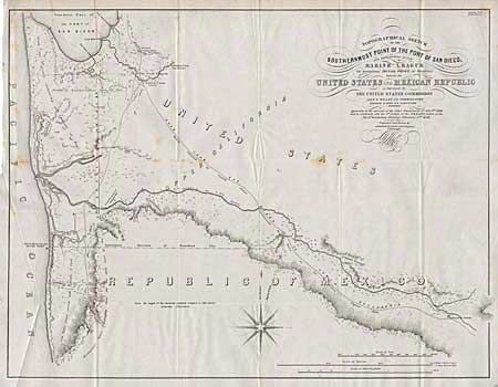
Subject: California & Mexico

Period: 1849 (published)

Publication: Senate Doc #34, 31st Congress, 1st Session

Color: Black & White

Size:
22.5 x 17.5 inches
57.2 x 44.5 cm
Download High Resolution Image
(or just click on image to launch the Zoom viewer)

This was the critical map of the boundary survey. Initial negotiations had broken down over a Mexican demand that Mexico be given the port of San Diego and the determination of the length of a league. It provides interesting detail in the vicinity of San Diego and along with its companion map of the Vicinity of the Gila River determined the anchor points for the new border. The map is full of interesting information and is visually attractive with calligraphy title and a large compass rose.

References: Wheat (TWM) #616.

Condition: B

A couple foxing spots, else clean and bright.

Estimate: $250 - $300

Sold for: $140

Closed on 3/7/2001

Archived