Catalog Archive
Auction 94, Lot 145

"Plat of the Northern Boundary Line of the State of Indiana…",
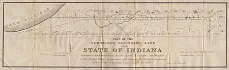
Subject: Indiana

Period: 1827-28 (published)

Publication: HR Doc. 187, State Papers 20th Cong., 1st Session

Color: Black & White

Size:
31 x 9 inches
78.7 x 22.9 cm
Download High Resolution Image
(or just click on image to launch the Zoom viewer)

Surveyed in conformity with the Act of Congress, "To authorize the President of the United States to ascertain and designate the Northern Boundary of the State of Indiana" passed March 2nd, 1827. Map shows the 1827 boundary line surveyed by E.P. Kendrich and an earlier line to the north surveyed in 1817 to ascertain the northern boundary of the State of Ohio.

References: Karpinski (FC) #663.

Condition: B

Scattered foxing and light toning to paper.

Estimate: $80 - $100

Sold for: $65

Closed on 3/7/2001

Archived