Subject: California
Period: 1848 (dated)
Publication: Mason's Report, Doc #1, 30th Congress, 2nd Session
Color: Black & White
Size:
18.2 x 9.5 inches
46.2 x 24.1 cm
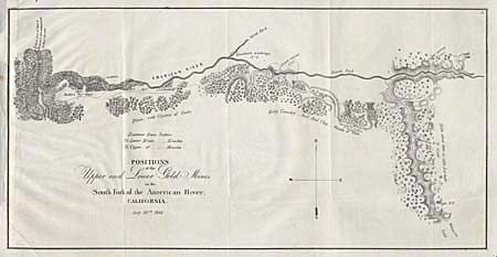
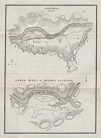
Pair of the earliest printed maps to actually name and locate gold discoveries in California. Gold was first discovered in January, 1848 and Sutter tried in vain to keep the discovery quiet. In July, Col. Mason, the Military Governor of California, toured the diggings and sent a report to the President officially announcing the discovery of gold. These maps were a part of this report, and spawned the great CALIFORNIA GOLD RUSH. The first map, (18.2 x 9.5")", titled "Positions of the Upper and Lower Gold Mines on the South Fork of the American River, California. July 20th, 1848." It covers the country along the American River from its junction with the Sacramento River to just above Weber's Creek. It shows "Sutter's Fort" and numerous other diggings. The second map, (6.5 x 9"), contains two maps within one border. The top one of the "Upper Mines", along the South Fork of the American River shows where "gold first found" by James W. Marshall. The lower map is of the "Lower Mines or Mormon Diggings", depicts numerous tents surrounding a store with a large area of the bar marked "gold". The maps were drawn by Lt. William T. Sherman, of later Civil War Fame, when he was adjutant to U.S. Military Gov. Mason.
References: Wheat (Gold) #51-52. Both folding, as issued.
Condition: A