Catalog Archive
Auction 92, Lot 82

"North America Divided into its Principall Parts where are distinguished the serveral States which belong to the English, Spanish, and French", Berry/Sanson

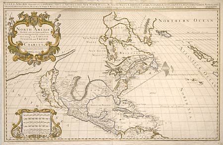
Subject: North America

Period: 1680 (dated)

Publication: A Collection of Maps of the World

Color: Hand Color

Size:
35 x 22.2 inches
88.9 x 56.4 cm
Download High Resolution Image
(or just click on image to launch the Zoom viewer)

This scarce map is based on the Sanson/Jaillot map of 1674, corrected by William Berry to reposition the Strait of Anian above the large ISLAND OF CALIFORNIA. The Great Lakes are shown open-ended on the Sanson model. English claims are prominently shown and named, including the first appearance of the name Pennsylvania. In the southwest, Santa Fe is shown on the western bank of the "North R.", which empties into the "Sea of Vermejo". The map is very handsome with original outline coloring and large (fully colored) title and distance scale cartouches.

References: Mc Laughlin #74; Wagner #418; Leighly 75.

Condition: A

The extremely large map is made up of two joined sheets. Minor roughness in top margin and slight printer's crease, else fine.

Estimate: $6,500 - $7,000

Sold for: $5,500

Closed on 9/13/2000

Archived