Subject: World
Period: 1700 (circa)
Publication:
Color: Black & White
Size:
18.2 x 15.7 inches
46.2 x 39.9 cm
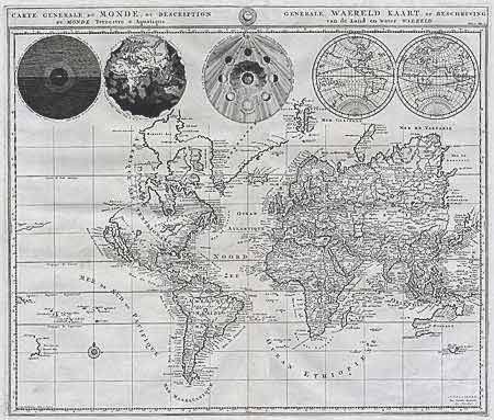
Striking map drawn on Mercator's projection with CALIFORNIA AS AN ISLAND and the "Detroit d'Anian" connected by dotted lines through the NORTHWEST PASSAGE to Buttons Bay, located to the west of Hudson Bay. In the Pacific is a small coastline of New Zealand. The northeast coast of Asia is severely truncated. Australia's northern coast is shown connected to New Guinea, along with a part of Van Diemen's Land. Across the top of the map are five spheres depicting Day and Night, the Flood, the phases of the moon, and the Western and Eastern hemispheres. Ref: Shirley #622. Very crisp impression. Some marginal soil at top and tiny bottom marginal split on fold, professionally repaired. $1000 RESERVE
References:
Condition: A+