Subject: Colonial Canada and United States
Period: 1689 (dated)
Publication:
Color: Hand Color
Size:
23 x 17.5 inches
58.4 x 44.5 cm
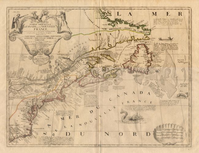
This fine map is considered the best 17th century representation of the geography of eastern Canada and New England. It is the earliest French map of the English Colonies in North America. Coronelli based the map on Jesuit sources, as well as Franquelin, Sanson, Bressani, and Le Bocage Boissale. Through his collaboration with Jean Baptiste Nolin, engraver to Louis XIV, Coronelli enjoyed access to the manuscripts from Jolliet, LaSalle, and the Jesuits. This beautifully engraved map includes detailed notes on the cultural and historic aspects of the various Jesuit expeditions. A number of place names and Indian tribal names appear for the first time. "Manitoualin", "Lac Taronto", "Chekagou" and "Fort Frontenac" are all named. It also shows the French political claims to both sides of the St. Lawrence and the Maritime provinces. The large title cartouche features two Indians hunting bear and stag. The distance scales are inset into a large shell and the ocean is embellished with sea monsters and a native canoe. This is the second state of the map with the address of the publisher changed to "Pont-Neuf". Ref: Kershaw, #160. Couple of very tiny tears in wide margin, repaired with archival tape. Map image fine. $2,750 RESERVE
References:
Condition: A