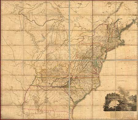
Subject: Eastern United States
Period: 1802-08 (dated)
Publication:
Color: Hand Color
Size:
56 x 48 inches
142.2 x 121.9 cm
This extremely influential map of the United States was first issued in 1796. This is the revised edition with "additions to 1802" and published by Arrowsmith after his move to 10 Soho Square in 1808. The 1802 version was used by Lewis and Clark to plan their famous expedition. The interior detail of the trans-Mississippi west was compiled largely from accounts supplied by Native Americans to Arrowsmith by the Hudson's Bay Company. The course of the Missouri River delineated on the map prompted Lewis and Clark to plot their course along the Missouri River, as it appeared to be the most direct route to the Pacific. Georgia's western border is on the Mississippi River. The westernmost road terminates at Nashville and all trails end at the Mississippi. Large engraved view of Niagara Falls is inset with the title. Below the view is a fascinating description of the falls. Issued dissected and linen-backed in four sections (each section measuring approximately 28 x 24"). Ref: Tooley (Mapping of America) p.99 - 3rd Issue. The map is in remarkable condition with only the faintest bit of lit toning and offsetting. The paper labels are intact, original light blue ribbon edging is partially detached, otherwise fine. A scarce and important American map.
References:
Condition: A