Catalog Archive
Auction 89, Lot 74

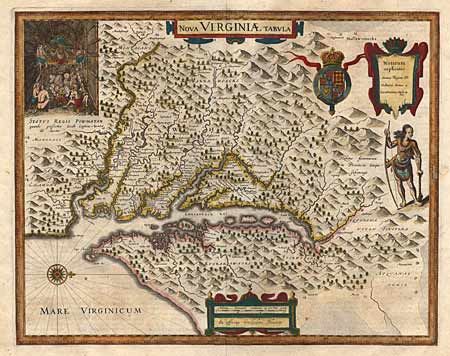
"An Accurate Map of Canada, with the Adjacent Countries Exhibiting the late Seat of War between the English & French in those Parts",

Subject: Colonial Canada and United States

Period: 1640-55 (published)

Publication: Universal Magazine

Color: Hand Color

Size:
13.5 x 10.5 inches
34.3 x 26.7 cm
Download High Resolution Image
(or just click on image to launch the Zoom viewer)

A very uncommon copper engraved map of the Great Lakes region that is filled with interesting detail, Indian place names, forts, and settlements. In full original color with an uncolored decorative cartouche. Still folded as issued. Ref: Jolly UNIV-98, Kershaw #966. Minor separation at fold intersection. Tear at binding edge extending nearly the entire length of the border with old repair. Overall very attractive and good condition.

References:

Condition: B

Estimate: $350 - $400

Sold for: $275

Closed on 12/8/1999

Archived