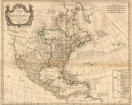
Subject: North America
Period: 1765 (dated)
Publication: T. Bowles (publisher)
Color: Hand Color
Size:
22.7 x 18.5 inches
57.7 x 47 cm
A very uncommon, interesting map of the continent showing political divisions after the Treaty of Utrecht, complete with key and colored accordingly. Several notations concerning the rights of the French awarded by the treaty, and other notations concerning discoveries in the west. The supposed River of the West is shown, by dotted line, emptying into the Pacific at an opening Discovered by Martin d Aguilar in 1603. The British colonies are shown extending to the Mississippi River, French Louisiana in the central region, with Spain controlling the entire western part. Large, uncolored, floral title cartouche. Vertical and horizontal folds, as issued. Ref: Sellers & Van Ee #115. Close margin at top with slight chipping into neatline, with some other marginal defects. Small ink spots; one near Bermuda and one in South Carolina, light toning on fold, else clean and crisp.
References:
Condition: B