Subject: Eastern Asia, Japan
Period: 1792 (circa)
Publication:
Color: Hand Color
Size:
19.9 x 28.8 inches
50.5 x 73.2 cm
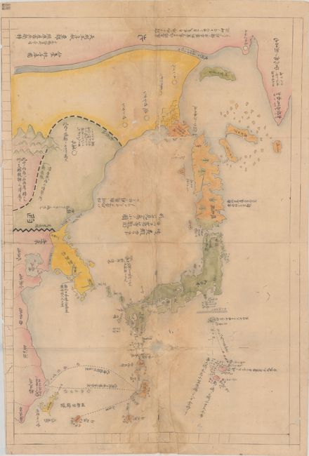
This is a manuscript edition of Hayashi Shihei's influential and controversial map of Japan and the surrounding region, which was first published in 1785 in his book, Sangoku Tsuran Zusetsu, along with several other maps. Hayashi's work focused on Japan's geopolitical position in relation to the Three Kingdoms during the Tenmei era and warned of the potential threat posed by Russia and China. The Three Kingdoms were regions with which the Tokugawa Shogunate had diplomatic relations, and included Ezo (Hokkaido) and the disputed Northern Territories, the Kingdom of Choson (Korea), and the Kingdom of Ryukyu (Okinawa). Hayashi recognized that both China and Russia had the potential to invade Japan due to their maritime powers, and that the Three Kingdoms could help serve as an initial defense. At the time, Japan still operated under a strict isolationist policy and, therefore, adhered to passive defense policies. The Tokugawa Shogunate determined that Hayashi's work, which was critical of the Japanese government, was not officially sanctioned and banned the book in 1792. Hayashi's work was seized and the woodblocks were destroyed, however manuscript copies of the maps were secretly reproduced and circulated.
The map depicts Japan, the Three Kingdoms, and parts of Russia and China, noting several travel routes and their distances. This map remains controversial today due to its depiction of the Liancourt Rocks, known by Koreans as Dokdo and by the Japanese as Takeshima, within the Sea of Japan. These administration of these islets has long been contested between Korea and Japan, and Hayashi notes them as belonging to Korea on the map.
References:
Condition: B
Drawn on rice paper with dampstaining through the center of the map. There are a number of small worm tracks throughout the map that have been left unrepaired, as well as two 1-1.5" worm holes that have been repaired with Japanese tissue. Fortunately the larger worm holes are in blank areas of the map, so overall there is only small loss of image. There are several long separations along the vertical fold that have also been archivally repaired, resulting in some mismatching of the image across the fold.