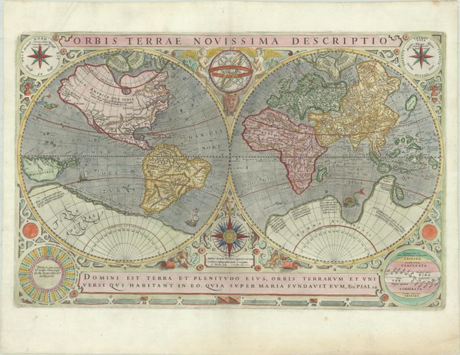
Subject: World
Period: 1602 (dated)
Publication:
Color: Hand Color
Size:
20.4 x 13.2 inches
51.8 x 33.5 cm
This is the first of two world maps engraved by Jodocus Hondius for Parisian publisher Jean Le Clerc. The map is based on Rumold Mercator's double-hemisphere map from 1587 (see Shirley #157), which in turn was based on his father's great world map of 1569. The North Pole is depicted as a landmass surrounding a sea from which four rivers radiate and there is a well depicted Northwest Passage. There is a huge Terra Australis, and the lands of Maletur and Beach (from the travel account of Marco Polo) are noted along the coast in the vicinity of present-day Australia with a large island labeled Iava Minor located in the same region. Japan is shown in a kite-shaped configuration, with the fictitious Satyrorum insule (Satyr's Island) shown above. Hondius updated Mercator's map by eliminating the bulge in the southwest coast of South America and adding the islands of Queen Elizabeth at the southern tip. In addition, Hondius elongated New Guinea, added several islands to its east.
The hemispheres are surrounded by an elaborate decorative border with an armillary sphere and 32-point compass rose tucked between the hemispheres. Hondius has balanced the title at top with one of his favorite quotations from the Psalms at bottom. The composition is completed with several diagrams in the corners, including two wind roses with the wind names in Dutch and Italian, a diagram of the phases of the moon, and a final diagram of the climatic zones. Le Clerc's map was issued both separately and in editions of Mercator-Hondius atlases and Le Clerc's own atlas (Theatre Geographique du Royaume de France). This is the third state, dated 1633, with the coastline of Terra Australis partially erased and without the line of small islands between New Guinea and South America. Blank verso.
References: Shirley #233.
Condition: A
A crisp impression on a bright sheet with a small bunch of grapes watermark. There is minor toning and soiling along the edges of the sheet.