Subject: North Atlantic
Period: 1720 (circa)
Publication:
Color: Hand Color
Size:
39.1 x 23.1 inches
99.3 x 58.7 cm
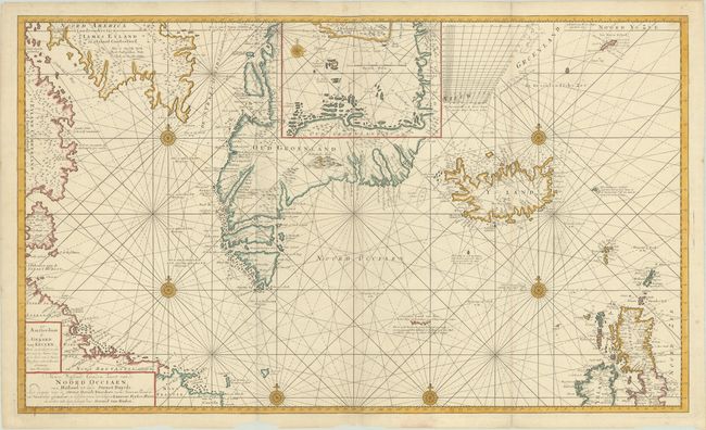
This superb sea chart is centered on Greenland and includes Iceland, northern Britain, and part of the coast of eastern Canada. Special attention is paid to the mapping of Greenland, especially the western coast, which has excellent navigational information for whalers, such as rocks, shoals, depth soundings and many tiny islands. The southern tip of Greenland is depicted as several large islands, and the coastline is still quite conjectural. A large inset map within Greenland gives a close-up view of Disko Bay on the west coast of Greenland. The chart is filled with rhumb lines, seven compass roses, and interesting notations. One particular notation relates to the mythical island of Friesland, which is depicted as a partial coastline with the accompanying explanation: "The Sunken Land of Bus is nowadays nothing but breakers—a quarter of a mile in length—amidst turbulent waters. For many years, it was a large island known as Freesland, spanning a circumference of one hundred miles and home to various villages." On two sheets, joined.
References: Koeman, Van Keulen [206].
Condition: A
A sharp impression, issued folding on bright sheets with several chips along the bottom edge, not affecting the image. There are a few short separations and tears along the edges of the sheet that have been repaired on verso, only one of which enters the image (1") at top left.