Subject: North Carolina
Period: 1935 (circa)
Publication: Our U.S.A. - A Gay Geography
Color: Printed Color
Size:
11.8 x 8.6 inches
30 x 21.8 cm
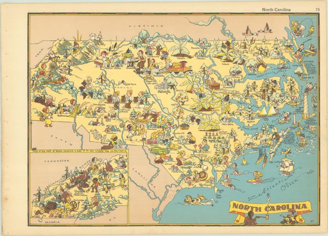
This splashy "cartograph" was issued in White's Our U.S.A. - A Gay Geography. It is filled with cartoonish imagery representing the state's recreation, culture, industry, and natural resources, including a Tarheel in the forest, the Wright Brothers taking flight in Kitty Hawk, the Cape Hatteras Lighthouse, the "Jugtown" potters, lots of fruit farming in the central part of the state, and many references to the state's tobacco trade. An inset at bottom left extends coverage to the western part of the state, showing the Cherokee Reservation, Asheville, and Chimney Rock. As one might expect from a map showing the South from this era, there are some unfortunate racial caricatures. The banner-style title cartouche features an Indigenous man passing a peace pipe to a colonist.
Ruth Taylor White's charming pictorial maps are among the most popular collectible maps of the early 20th century. Shortly after the publication of the first edition of Our U.S.A. - A Gay Geography in 1935, the New York Times reviewed it as follows: "Any one who remembers his childhood efforts to visualize Kentucky as something more than the green spot on the map, or New York as the pink State, will appreciate this volume. Brilliantly colored pictorial maps of the same order which have been amusing adults for the past decade show the United States and their Territories as active, picturesque entities" (November 17th, 1935).
References: Rumsey #7823.076.
Condition: A
A clean and bright example, with just a touch of toning and binding holes in the left blank margin.