Subject: World
Period: 1785 (dated)
Publication: A Voyage to the Pacific Ocean...
Color: Black & White
Size:
22.9 x 14.8 inches
58.2 x 37.6 cm
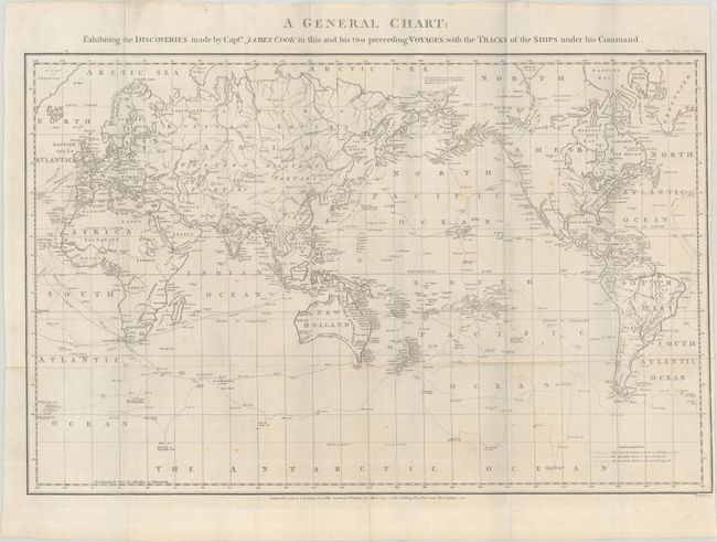
Captain James Cook (1728-1779) is best known for his three voyages to the Pacific (1768-71; 1772-75; and 1776-79). His discoveries radically changed the western understanding of the world in the late 18th century. He was the first to circumnavigate and chart New Zealand and provided the earliest European accounts of exploration along the eastern coast of Australia and the Hawaiian Islands. On February 14th, 1779, he was killed on Hawaii after attempting to kidnap the chief of the island.
Many contemporary accounts of Cook’s voyages, including charts and engravings, appeared in the late 18th century. The first official account of Cook’s first voyage was published in 1773 by John Hawkesworth in Volumes II and III of An Account of the Voyages Undertaken by the Order of His Present Majesty for Making Discoveries in the Southern Hemisphere... William Strahan and Thomas Cadell published the first official accounts of the second and third voyages in 1777 and 1784. Accounts of his exploration were subsequently translated into French, German, and Dutch.
This uncommon map is similar to the one compiled by Lieut. Henry Roberts from Cook's surveys after the third expedition. It centers on Australasia and traces the routes of the Endeavour (1768-71) and Resolution (1772-75 and 1776-80) with notes along the tracks. A key at bottom right corresponds the tracks to each voyage. Alaska is shown with a fairly correct shape, with a note to the north indicates that further northward progress was made impossible due to ice extending from continent to continent. The South Pacific is filled with islands, New Zealand is fully formed, and Tasmania is still attached to Australia. The map was published by J. Stockdale and John Fielding in an octavo edition of Cook's voyages. Engraved by Hatchett.
References:
Condition: B+
Issued folding on a sheet with the watermarks of "J. Whatman" and a fleur-de-lis coat of arms. There are light spots, a few short separations at fold intersections, and a 1.5" edge tear at right that has been closed on verso with archival tape. Narrow margin at right.