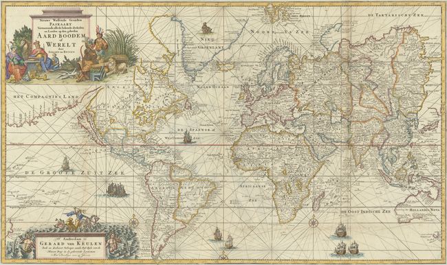
Subject: World
Period: 1728 (circa)
Publication:
Color: Hand Color
Size:
39.4 x 23.4 inches
100.1 x 59.4 cm
This scarce and spectacular chart of the world is a larger and more elaborate work than the world map included in Johannes van Keulen's 1682 edition of Zee-Fakkel. Drawn on Mercator's Projection, the chart features California as an island with an indented northern coastline. To its north and west is the Straet Anian that divides North America from a massive Compagnies Land that extends far to the east. Within North America, New York, Virginia and Carolina are named along the east coast with a large unnamed lake (Lake May) in the southeast. Further to the west, the Great Lakes are fully enclosed (though inaccurate) and a large unnamed lake is the source of the Colorado River. In Oceania, the chart presents only a partial southern coastline for Australia, which is still connected to New Guinea. In the bottom corners of the chart are partial coastlines for both New Zealand and Tasmania, further documenting the Dutch discoveries in the region. Gerard's map also features much more inland detail than his father's world map including scores of place names, rivers and mountains, many countries, and even a pair of bears in Greenland. The chart is lavishly decorated by rhumb lines, nine sailing ships, three compass roses, and two decorative cartouches featuring personifications of the four continents and Poseidon guarding the seas. Printed on two joined sheets. Not listed in McLaughlin. This is one of only three world maps published by the Keulen family.
References: Koeman, Van Keulen [199].
Condition: B+
Issued folding on "C&I Honig" watermarked paper that has been trimmed to the border on all sides by the binder. There is a hint of toning along the vertical folds at left and right and two tiny splits at the fold junctions.