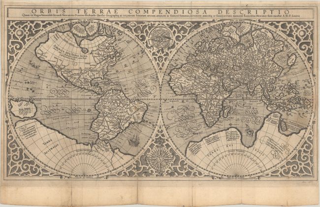
Subject: World
Period: 1587 (dated)
Publication:
Color: Black & White
Size:
20.3 x 11.3 inches
51.6 x 28.7 cm
This is a variant example of Mercator's world map that is nearly identical to the original. This beautiful double-hemisphere map features an elaborate strapwork border and an armillary sphere and 32-point compass rose are tucked between the hemispheres. The North Pole is depicted as a landmass surrounding a sea from which four rivers radiate and there is a well depicted Northwest Passage. The huge Terra Australis is shown as a part of Tierra del Fuego, and the lands of Lucach, Maletur and Beach (from the travel account of Marco Polo) are noted along the coast in the vicinity of present day Australia with a large island labeled Iava Minor located in the same region. Japan is shown in a kite-shaped configuration, with the fictitious Satyrorum insule (Satyr's Island) shown above. South America has a bulge on its southwest coast, and New Guinea is depicted in a large, circular configuration. The map embodies many ancient authorities and is a wonderful view of classical cartography. Blank verso.
In his "Corrigenda and Addenda," Rodney Shirley identifies this variant that appeared in a Sotheby's auction in June 2000. The key differences are the first letter of the date is "A" instead of "A°" and a mountain range in East Africa (Ethiopia) has been removed. Shirley notes that it is uncertain whether this second plate was produced in Mercator's workshop or a later production by someone else. It is possible that Jodocus Hondius prepared this plate in the 1620s to replace the old plate that had been damaged in two places. Shirley concludes that "examination of the map and its paper has not raised doubts as to its authenticity." We were unable to locate any other examples of this map in the last 30 years.
References: Shirley #157A.
Condition: B+
Issued folding with light wear along the fold lines and archival repairs to several short fold separations. There are a couple of light stains at right and some printer's ink residue.