Subject: World, North Pole
Period: 1702 (circa)
Publication: Atlas Novus
Color: Hand Color
Size:
13.9 x 9.3 inches
35.3 x 23.6 cm
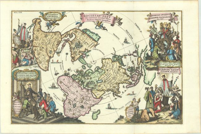
An exquisite depiction of the world from the Jesuit mathematician's series of sharply engraved maps. The map is presented on a north polar projection and shows California as an island. Large shining, star-like symbols of the Jesuits mark the locations of Jesuit missions throughout the world. Each corner is richly engraved with allegorical scenes of four Jesuit saints: St. Ignatius Loyola, founder of the Jesuit order (bottom left); Father Joseph Anchieta, Apostle of Brazil (top left); Andreas Oviedus, Patriarch of Ethiopia (top right); and St. Francis Xavier, Apostle of India (bottom right). There are many cherubs supporting a number of Latin plaques such as the one under St. Francis Xavier quoting Matthew 28, " Therefore go and make disciples of all nations, baptizing them in the name of the Father and of the Son and of the Holy Spirit." The map is further adorned with ships and sea monsters.
References: Shirley #629; Shirley (BL Atlases) T.SHER-1a #33.
Condition: A
A crisp impression issued folding on a bright sheet with a hint of toning along the sheet's edges.