Subject: World
Period: 1690 (circa)
Publication: Atlante Veneto
Color: Hand Color
Size:
24.2 x 18 inches
61.5 x 45.7 cm
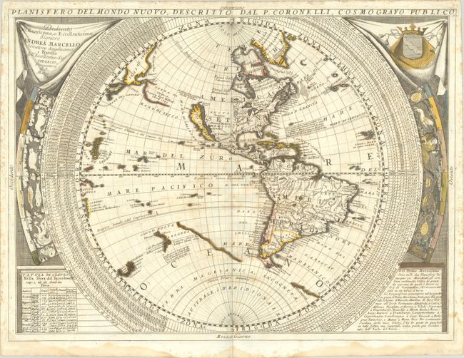
Vincenzo Coronelli was Italy's most esteemed cartographer and globe-maker. A member of the Franciscan order, he also founded the society Accademia Cosmografica degli Argonauti. Coronelli's Atlante Veneto, a compendium of geographical and scientific knowledge in twelve massive volumes, included these magnificent maps. They are based on his large globe gores of 1688. In North America, the recent French explorations in the Mississippi valley are recorded and a huge French Louisiana takes in most of the continent at the expense of the British colonies. California is shown as an Island with a huge Detroit d'Anian separating it from Terre de Jesso off the coast of Asia. The discoveries of Tasman are shown in the South Pacific (with an erroneous date of 1684), but the Solomon Islands are not shown. Remnants of the coastline of the southern continent exist including the label Terra de Pappagalli (Land of Parrots) just south of Africa. In Africa, the Blue Nile rises from a large lake in Ethiopia and the central equatorial lakes are the source of the Niger River. In Asia, the Caspian Sea is drawn closer to its modern shape but an unusual gulf appears in the northeast Asia. Around the circumference of each hemisphere are wide latitude bands and the signs of the zodiac, which give the maps a very bold appearance. Several short cracks in the plate are visible at the bottom of the eastern hemisphere sheet.
References: McLaughlin #105; Shirley #548.
Condition: B
Contemporary color on paper with fleur-de-lis watermarks. There is scattered foxing, three 1" segments with hairline (very narrow) loss along the centerfolds, and one tiny chip in a decorative element of the western sheet due to oxidation of the green pigment. Dampstains at bottom just enter the map corners.