Subject: North America, Texas
Period: 1845 (published)
Publication:
Color: Hand Color
Size:
12.3 x 15.3 inches
31.2 x 38.9 cm
The beginning of the nineteenth century saw a period of rapid market growth and innovation in the map publishing world. Increased literacy and public interest in new frontiers and colonies overwhelmed the market because it was oriented toward the small, affluent market of the previous century. With the intent to fill this void, The Society for the Diffusion of Useful Knowledge (SDUK) was founded in 1828 in London, by Lord Brougham and a group of men dedicated to the education of the aspiring working class and the Utilitarian ideal of 'Knowledge is Power.' The society produced an array of education materials, but the series of maps was one of their most successful ventures. A number of engravers and printers were used to produce the maps, which eventually exceed 200 sheets, and continued to be published after the Society as a whole ceased to function.
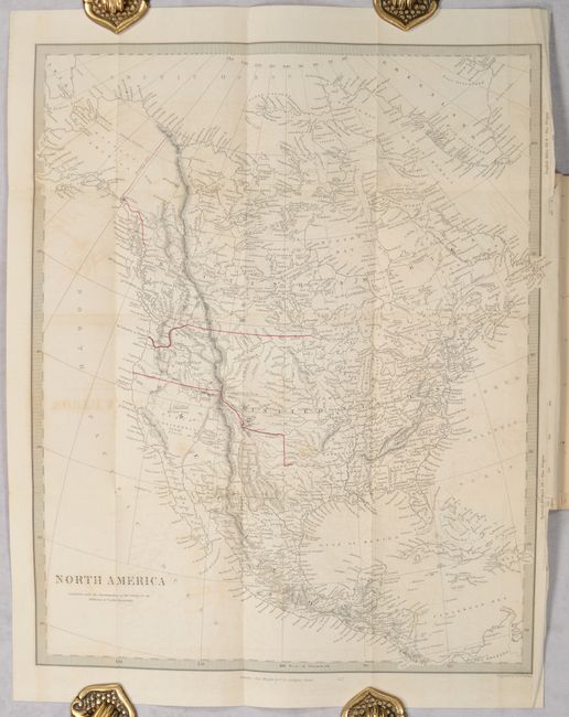
This detailed and finely engraved map portrays an Independent Texas, with Mexico controlling Nueva California. The boundary between Canada and the United States has been drawn to favor a British perspective, following the Columbia River to the Pacific Ocean. Filled with well-developed topography, the map names numerous forts, trading posts, and Indian tribes. The Great Salt Lake is not present, but L. Youla is located in its vicinity with the American Fur Depot on its eastern shore. The R. Buenaventura extends to the Pacific from two branches, one originating from a large swamp in the Great Basin. The course of the Snake River is fairly accurate, but the Colorado River originates too far north and rushes to the Sea of Cortez in a straight line. The map locates the 3 Butes, important landmarks on the Oregon Trail, in present-day Idaho. Lake Michigan retains its erroneous elongated shape. Distance scales outside of border give English Miles and Spanish Leagues. Engraved by J. & C. Walker and published by Charles Knight.
The map folds into Thomas Falconer’s 47-page defense of the British position in The Oregon Question. Falconer’s recommendations included the 49th parallel for much of the boundary, which was adopted. However, the region around the Puget Sound that he sought to be British ultimately became American soil.
References:
Condition: B
The folding map has light offsetting and two short binding tears at right that have been closed on verso with archival tape. Text has light toning and is missing the front wrapper.