Subject: North America, Texas
Period: 1844-48 (circa)
Publication:
Color:
Size:
12.4 x 15.1 inches
31.5 x 38.4 cm
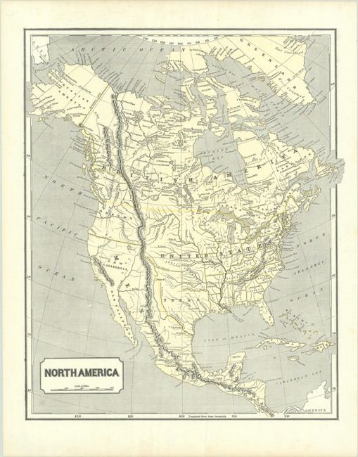
A. North America, by Morse & Breese, from Morse's North American Atlas, circa 1844, printed color. This cerographic map is a very early example of printed color. Sidney Morse invented the wax engraving method used to print this map. The map depicts an independent Republic of Texas in its stovepipe configuration, as well as a large Iowa Territory that extends north to the Canadian border. Indian Territory occupies the land north of Texas, and Oregon includes present-day Washington. Remnants of two spurious rivers still appear in the Great Basin.Mexico controls the Southwest and California, and Alaska is Russian America. The boundary above Oregon Territory is colored to show both the American claim into British Columbia and the eventually settled boundary. Printed in yellow and black. Condition: A sharp impression on a bright sheet with minor foxing that is only visible in the blank margins. (A)
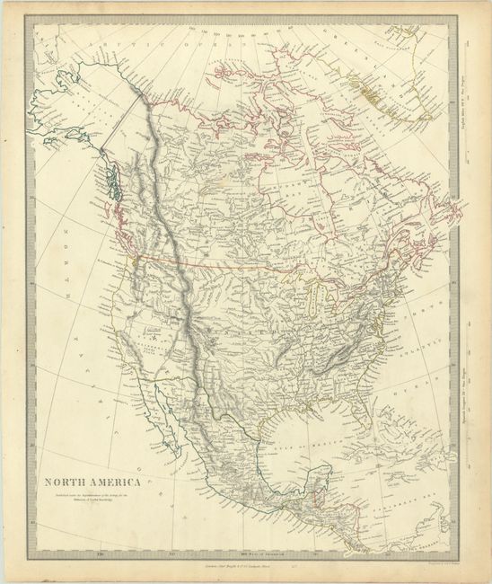
B. North America, by SDUK Society for the Diffusion of Useful Knowledge, circa 1848, hand color. This detailed and finely engraved map portrays an Independent Texas, with Mexico controlling Nueva California, although on this example the colorist has drawn the border along the Gila River. The boundary between Canada and the United States is left ambiguous, leaving the ownership of Oregon Territory (here labeled Columbia) unknown, which is unusual for a British map (the colorist on this example draws the present-day border). Filled with well-developed topography, the map names numerous forts, trading posts, and Indian tribes. The Great Salt Lake is not present, but L. Youla is located in its vicinity with the American Fur Depot on its eastern shore. The R. Buenaventura extends to the Pacific from two branches, one originating from a large swamp in the Great Basin. The course of the Snake River is fairly accurate, but the Colorado River originates too far north and rushes to the Sea of Cortez in a straight line. The map locates the 3 Butes, important landmarks on the Oregon Trail, in present-day Idaho. Lake Michigan retains its erroneous elongated shape. Distance scales outside of border give English Miles and Spanish Leagues. Engraved by J. & C. Walker and published by Charles Knight. Condition: There is light soiling with light toning confined to the sheet's edges. (B+)
References:
Condition:
See description above.