Current Auction
Lot 83
Current Auction

"L'Amerique Septentrionale qui fait Partie des Indes Occidentales. Dressee Selon les Dernieres Relations des Voiageurs et Suivant les Nouvelles Observations...", Chiquet, Jacques

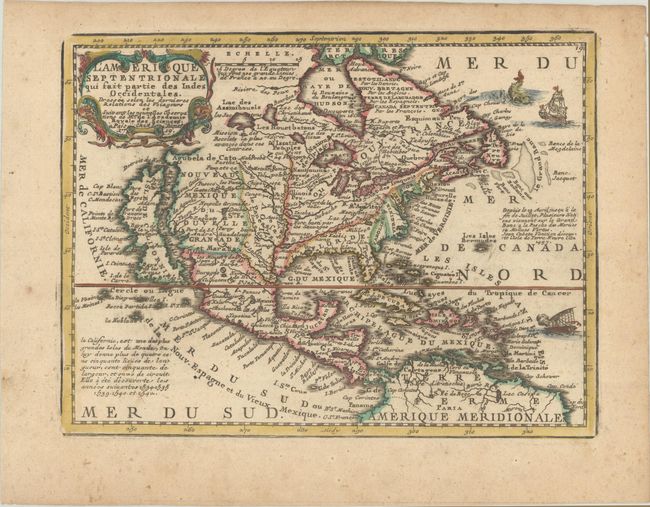
Subject: Colonial North America

Period: 1719 (dated)

Publication: Le Nouveau et Curieux Atlas Geographique et Historique

Color: Hand Color

Size:
8.6 x 6.6 inches
21.8 x 16.8 cm
Download High Resolution Image
(or just click on image to launch the Zoom viewer)

Charming, exquisitely detailed map of the continent featuring the island of California with an indented northern coast and Cap Blanc, Port des Roys and Pointe de la Cair at its northern end. The British colonies are shown confined east of the Appalachians, with France in control of the region between there and the Mississippi River. Spain controls all of the West and Florida. Several short notes fill the map, including information on the island of California and the fishing banks off the coast of Newfoundland. The decorative title cartouche is flanked by two serpents. Two ships and a sea monster fill the Atlantic.

References: McLaughlin #191; Mickwitz & Miekkavaara #43-6; Shirley (BL Atlases) T.MEN-1b.

Condition: B+

A nice impression on a lightly toned sheet with tiny spots of foxing that are mostly confined to the edges of the sheet.

Estimate: $350 - $425

Current High Bid:
$0

Reserve: Reserve Not Met
Next Bid: $180

Bid Increments
$100 - $249$10
$250 - $499$25
$500 - $999$50
$1,000 - $2,499$100
Terms & Conditions