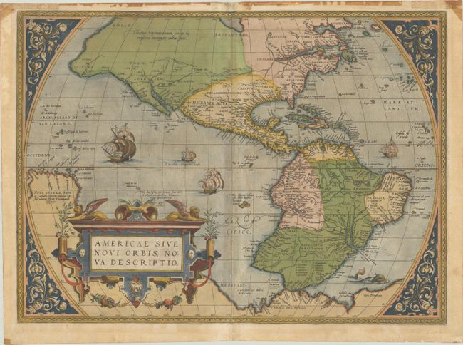
Subject: Western Hemisphere - America
Period: 1571 (published)
Publication: Theatrum Orbis Terrarum
Color: Hand Color
Size:
19.9 x 14.5 inches
50.5 x 36.8 cm
This is one of the most famous maps of America, and one that had enormous influence on the future cartography of the New World. Frans Hogenberg engraved this map, and it is primarily based on Gerard Mercator's great multi-sheet world map of 1569. The most recognizable features of the map are the bulbous Chilean coastline and the exaggerated breadth of the North American continent. North America shows a lengthy St. Lawrence River reaching across the continent to nearly meet the fictitious, westward flowing Tiguas Rio. The strategically placed title cartouche hides the unknown South Pacific and therefore most of the conjectural great southern continent, which is shown attached to both New Guinea and Tierra del Fuego.
This is from the uncommon first plate (second state), with Latin text on verso, published in 1571. This plate had a relatively short life and was published only between 1570 and 1575. There are two small plate cracks in the border that were present in all editions of this plate. These cracks were repaired for the 1575 edition, but the plate quickly developed another crack and was subsequently replaced by a new plate for the 1579 edition.
References: Burden #39.2; Goss (NA) #11; Van den Broecke #9.2.
Condition: B+
A crisp, early impression with full contemporary color on a lightly toned sheet with a small coat of arms watermark and a printer's crease at top left. There are professional repairs to several short separations along the centerfold and to two tiny tears in the image. There are dark stains along the top edge of the sheet, which has been archivally reinforced with tissue on verso; the stains could be easily concealed if the map were framed.