Subject: Cartographic Miscellany, Game, Eastern Asia
Period: 1944 (published)
Publication:
Color: Printed Color
Size:
20.3 x 14.3 inches
51.6 x 36.3 cm
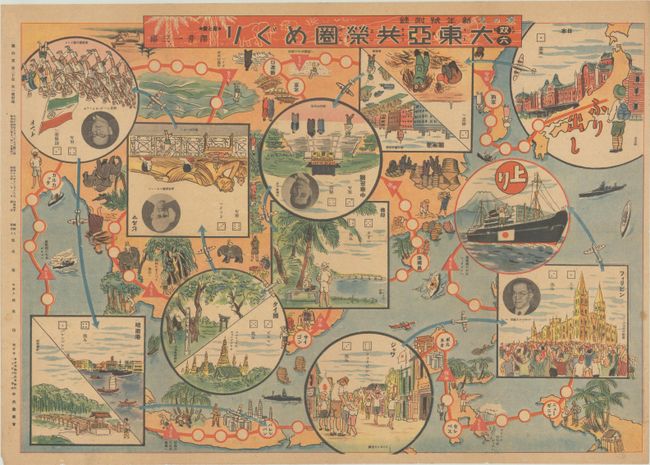
This sugoroku was designed to instill nationalistic pride and support of the Japanese Imperial Army during World War II. The game begins at top right, in Tokyo, and then turns upside down and travels to China, Myanmar, and India. Game play continues right-side up to go through Singapore, Java, and New Guinea, ending on a Japanese warship in the Pacific Ocean. Insets depict places along the route and give additional game instructions, and also include photo portraits of the leaders of Imperial Japan's puppet states: Wang Jingwei (China), Ba Maw (Burma), Subhas Chandra Bose (India), Ba Maw (Burma), and José P. Laurel (the Philippines). This map was published in Showa 19 (1944) and is a fascinating piece of Japanese propaganda that glorifies their military power while also touting their friendship with countries under occupation. Created by Ichisaburo Sawai and published by Chuo Nogyokai.
References: Rumsey #11107.
Condition: B+
Issued folding, with light toning, a few spots of soiling, and several short splits along the folds.