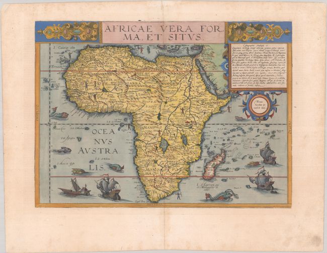
Subject: Africa
Period: 1593 (published)
Publication: Speculum Orbis Terrae
Color: Hand Color
Size:
17.8 x 12.8 inches
45.2 x 32.5 cm
This exceedingly rare map is an interesting amalgamation of cartographical sources. Cornelis de Jode prepared this map for the second edition of the Speculum after his father Gerard's death in 1591. It replaced the African map of the first edition that had been attributed to Gastaldi. This map retains the continental outline from Gastaldi with the interior based primarily on Mercator's world map of 1569. This is most evident in the river systems, including Sachaf Lac as the source of the Zabere (Zembere), Cuama and R. d S. Spirito rivers in southern Africa. The map also incorportates information from Ortelius including the placement of Zanzibar on the southwest coast. The map is beautifully adorned with ships and sea monsters and representations of the native people scattered across the map. Unfortunately, Cornelis's atlas met the same fate as that of his father's atlas, with very few copies being sold. On the death of Cornelis, the copper plates were sold to Jan Baptist Vrients, the publisher of Ortelius's atlas, who acquired them merely to stop their re-issue. As a result, the map is very rare. Latin text on verso.
References: Betz #27; Norwich #19; Van der Krogt (Vol. III) #8600:32B.
Condition: A
A nice impression with old color on a sheet with a crossed arrows watermark. In the blank margins, there are archival repairs to two small chips in the top corners and light soiling and foxing. Remnants of hinge tape on verso.