Catalog Archive
Auction 208, Lot 592

"The Ganges from the Calligonga, to Its Confluence with the Megna or Burrampooter: and the Megna from Thence to the Head of the Luckia River", Rennell, James (Major)

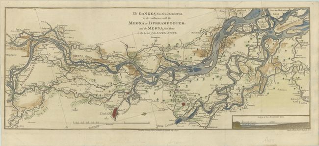
Subject: Meghna & Padma Rivers, Bangladesh

Period: 1785 (dated)

Publication:

Color: Hand Color

Size:
23.5 x 9.4 inches
59.7 x 23.9 cm
Download High Resolution Image
(or just click on image to launch the Zoom viewer)

This map shows the river basin of the Meghna and Padma Rivers within Bangladesh, with Dhaka shown near bottom center. The Padma River, which begins as the Ganges River in India, and the Meghna River empty into the Bay of Bengal, forming the Ganges Delta. The inset at bottom right illustrates the rise in the water level of the Jalangi River during the rainy season. A fleur-de-lis orients north to the bottom left corner of the map. The map was originally drawn by James Rennell, the Surveyor General of the East India Company, and published in A Bengal Atlas circa 1780. This example was copied by C. C. Glassbach for a later publication.

References:

Condition: A

A crisp impression, issued folding on a sheet with a large "4" watermark, now flattened. There is a long, diagonal printer's crease at top right and minor marginal soiling.

Estimate: $275 - $350

Sold for: $200

Closed on 4/22/2026

Archived