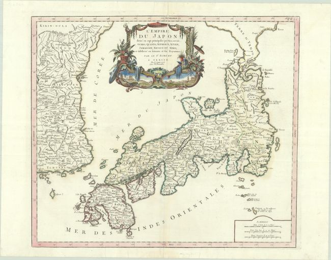
Subject: Japan & Korea
Period: 1778 (dated)
Publication: Atlas Universel
Color: Hand Color
Size:
21.1 x 18.4 inches
53.6 x 46.7 cm
Large, finely engraved map of Japan with a distinctively French style title cartouche containing two small landscapes. The map draws heavily on the previous work of Bellin, but includes a number of improvements to Terre d'Yedso (Hokkaido) similar to the manuscripts of Engelbert Kaempfer. The fictitious island of Matsumae is removed and now Matsaki is shown as a part of Yedso. The provinces are clearly outlined and there are many place names. The eastern part of the Korean peninsula is also shown with a good amount of detail. The sea between Korea and Japan is named both the Mer de Coree and the Mer du Japon, reflecting a compromise to the long-standing dispute over the name of this sea. This great map was to influence the cartography of Japan into the 19th century. Santini first published a complete re-engraving of Robert de Vaugondy's map circa 1776; this is the second state, with Remondini's imprint added and republished in 1784.
References: Hubbard #114.2; Pedley #410; Walter, OAG #118.
Condition: B+
A crisp impression on a bright sheet with an "R" watermark, contemporary outline color in the map and later color in the cartouche. There are centerfold separations at top and bottom that have been archivally repaired, with the separation at top slightly misaligned.